No edit summary |
m (Mishter Miner moved page County of Marquette to Marquette County) |
||
| (2 intermediate revisions by the same user not shown) | |||
| Line 1: | Line 1: | ||
| − | |||
| − | |||
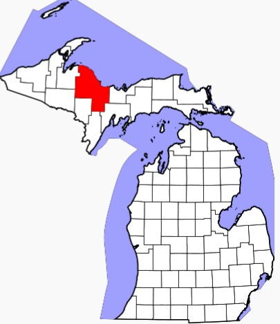
'''Marquette County''' is a county in the Upper peninsula of the US state of Michigan. As of the 2010 census, the population was 67,077.<sup>[2]</sup> The county seat is Marquette.<sup>[3]</sup>Marquette County is the largest county in land area in Michigan, and the most populous county in the Upper Peninsula of Michigan. |
'''Marquette County''' is a county in the Upper peninsula of the US state of Michigan. As of the 2010 census, the population was 67,077.<sup>[2]</sup> The county seat is Marquette.<sup>[3]</sup>Marquette County is the largest county in land area in Michigan, and the most populous county in the Upper Peninsula of Michigan. |
||
| Line 7: | Line 5: | ||
[[File:IMG_20140824_180750.jpg|thumb|300px|Location.]] |
[[File:IMG_20140824_180750.jpg|thumb|300px|Location.]] |
||
| − | == |
+ | == Geography == |
| − | The county is named for Father Marquette, a Jesuit missionary. It was set off in 1843 and organized in 1851.<sup>[1]</sup> The Huron Mountainsare located in the county. According to the 2010 census, the county has a total area of 3,424.54 square miles (8,869.5 km<sup>2</sup>), of which 1,808.40 square miles (4,683.7 km<sup>2</sup>) (or 52.81%) is land and 1,616.14 square miles (4,185.8 km<sup>2</sup>) (or 47.19%) is water.<sup>[4]</sup> |
+ | The county is named for Father [[Jacques Marquette]], a Jesuit missionary. It was set off in 1843 and organized in 1851.<sup>[1]</sup> The Huron Mountainsare located in the county. According to the 2010 census, the county has a total area of 3,424.54 square miles (8,869.5 km<sup>2</sup>), of which 1,808.40 square miles (4,683.7 km<sup>2</sup>) (or 52.81%) is land and 1,616.14 square miles (4,185.8 km<sup>2</sup>) (or 47.19%) is water.<sup>[4]</sup> |
=== Adjacent counties === |
=== Adjacent counties === |
||
| − | * Alger County (east) |
+ | * [[Alger County]] (east) |
| − | * Delta County (southeast) |
+ | * [[Delta County]] (southeast) |
| − | * Menominee County (south) |
+ | * [[Menominee County]] (south) |
| − | * Dickinson County (south) |
+ | * [[Dickinson County]] (south) |
| − | * Iron County (southwest) |
+ | * [[Iron County]] (southwest) |
| − | * Baraga County |
+ | * [[Baraga County]] (west) |
| − | * Houghton County (northwest, water boundary only, in Lake Superior) |
+ | * [[Houghton County]] (northwest, water boundary only, in Lake Superior) |
* Keweenaw County (north, water boundary only, in Lake Superior) |
* Keweenaw County (north, water boundary only, in Lake Superior) |
||
See also: List of counties bordering eight counties |
See also: List of counties bordering eight counties |
||
=== National protected areas === |
=== National protected areas === |
||
| − | * Hiawatha National Forest (part) |
+ | * [[Hiawatha National Forest]] (part) |
| − | * Huron National Wildlife Refuge |
+ | * [[Huron National Wildlife Refuge]] |
| − | * Ottawa National Forest (part) |
+ | * [[Ottawa National Forest]] (part) |
| − | == |
+ | == University == |
Northern Michigan University is a four-year university, established in 1899, located in Marquette, Michigan, on Michigan's Upper Peninsula. The school is home to over 9,000 students and offers over 100 academic programs leading to degrees at the levels of bachelor, associate, certificate, as well as several graduate programs. Their Teaching, Learning and Communication (TLC) program, which is the largest of its kind in the country, gives every student an IBM ThinkPad or Apple MacBook. NMU has the world's largest wooden dome, the Superior Dome. It is also home to the United States Olympic Education Center, or USOEC, one of only four US Olympic training centers and the only one affiliated with a university. Athletes receive scholarships and utilize the school's facilities training in several sports: Men's and Women's Weightlifting; Boxing; Men's and Women's Speedskating; Greco-Roman Wrestling; and Women's Freestyle Wrestling. |
Northern Michigan University is a four-year university, established in 1899, located in Marquette, Michigan, on Michigan's Upper Peninsula. The school is home to over 9,000 students and offers over 100 academic programs leading to degrees at the levels of bachelor, associate, certificate, as well as several graduate programs. Their Teaching, Learning and Communication (TLC) program, which is the largest of its kind in the country, gives every student an IBM ThinkPad or Apple MacBook. NMU has the world's largest wooden dome, the Superior Dome. It is also home to the United States Olympic Education Center, or USOEC, one of only four US Olympic training centers and the only one affiliated with a university. Athletes receive scholarships and utilize the school's facilities training in several sports: Men's and Women's Weightlifting; Boxing; Men's and Women's Speedskating; Greco-Roman Wrestling; and Women's Freestyle Wrestling. |
||
| − | == State trunkline |
+ | == State trunkline highways == |
| − | Main article: List of state highways in Marquette County |
+ | Main article: [[List of state highways in Marquette County]] |
| + | Highways include: |
||
| − | Map of the county's highways |
||
| − | * US 41 |
+ | * [[US 41]] |
| − | * M‑28 |
+ | * [[M‑28]] |
| − | * M‑35 |
+ | * [[M‑35]] |
| − | * M‑94 |
+ | * [[M‑94]] |
| − | * M‑95 |
+ | * [[M‑95]] |
| − | * M‑553 |
+ | * [[M‑553]] |
In addition to the 169.42 miles (272.66 km) of state highways in the county, the Marquette County Road Commission maintains 283.85 miles (456.81 km) of primary county roads which include County Road 492 (CR 492), and 988.25 miles (1,590.43 km) of secondary county roads. The road commission provides maintenance such as snow removal under contract with the Michigan Department of Transportation for the state trunklines.<sup>[5]</sup> The commission was also planning to buildCR 595 in the next few years.<sup>[6]</sup> The project was canceled after the permit was denied by the Michigan Department of Environmental Quality and the funding for the project was diverted by the commercial interests backing construction.<sup>[7]</sup> |
In addition to the 169.42 miles (272.66 km) of state highways in the county, the Marquette County Road Commission maintains 283.85 miles (456.81 km) of primary county roads which include County Road 492 (CR 492), and 988.25 miles (1,590.43 km) of secondary county roads. The road commission provides maintenance such as snow removal under contract with the Michigan Department of Transportation for the state trunklines.<sup>[5]</sup> The commission was also planning to buildCR 595 in the next few years.<sup>[6]</sup> The project was canceled after the permit was denied by the Michigan Department of Environmental Quality and the funding for the project was diverted by the commercial interests backing construction.<sup>[7]</sup> |
||
| − | == |
+ | == Demographics == |
{| |
{| |
||
!Historical population |
!Historical population |
||
| Line 151: | Line 149: | ||
The median income for a household in the county was $46,875, and the median income for a family was $52,083. The per capita income for the county was $22,170. About 6.4% of families and 12.5% of the population were below the poverty line, including 20.3% of those under age 18 and 12.5% of those age 65 or over. |
The median income for a household in the county was $46,875, and the median income for a family was $52,083. The per capita income for the county was $22,170. About 6.4% of families and 12.5% of the population were below the poverty line, including 20.3% of those under age 18 and 12.5% of those age 65 or over. |
||
| − | == |
+ | == Government == |
The county government operates the jail, KI Sawyer International Airport, maintains rural roads, operates the major local courts, keeps files of deeds and mortgages, maintains vital records, administers public healthregulations, and participates with the state in the provision of welfare and other social services. The county board of commissionerscontrols the budget but has only limited authority to make laws or ordinances. In Michigan, most local government functions – police and fire, building and zoning, tax assessment, street maintenance, etc. — are the responsibility of individual cities and townships. |
The county government operates the jail, KI Sawyer International Airport, maintains rural roads, operates the major local courts, keeps files of deeds and mortgages, maintains vital records, administers public healthregulations, and participates with the state in the provision of welfare and other social services. The county board of commissionerscontrols the budget but has only limited authority to make laws or ordinances. In Michigan, most local government functions – police and fire, building and zoning, tax assessment, street maintenance, etc. — are the responsibility of individual cities and townships. |
||
=== Marquette County elected officials === |
=== Marquette County elected officials === |
||
| − | * Prosecuting Attorney: Matthew Wiese |
+ | * Prosecuting Attorney: [[Matthew Wiese]] |
| − | * Sheriff: Michael H. Lovelace |
+ | * Sheriff: [[Michael H. Lovelace]] |
| − | * County Clerk: Peter Dishnow |
+ | * County Clerk: [[Peter Dishnow]] |
| − | * County Treasurer: Anne Giroux |
+ | * County Treasurer: [[Anne Giroux]] |
| − | * Register of Deeds: Patricia A. Manley |
+ | * Register of Deeds: [[Patricia A. Manley]] |
| − | * Drain Commissioner: P. Michael Farrell |
+ | * Drain Commissioner: [[P. Michael Farrell]] |
| − | * Mine Inspector: John Carlson |
+ | * Mine Inspector: [[John Carlson]] |
<small>(information as of June 2013)</small><sup>[12]</sup> |
<small>(information as of June 2013)</small><sup>[12]</sup> |
||
| − | == Historical |
+ | == Historical markers == |
There are ten historical markers in the County,<sup>[13]</sup> namely: |
There are ten historical markers in the County,<sup>[13]</sup> namely: |
||
| − | * Cliffs Shaft Mine |
+ | * [[Cliffs Shaft Mine]] |
| − | * Dandelion Cottage |
+ | * [[Dandelion Cottage]] |
| − | * Father Marquette Park |
+ | * [[Father Marquette Park]] |
| − | * First Steam Railroad in Upper Peninsula |
+ | * [[First Steam Railroad in Upper Peninsula]] |
| − | * Ishpeming: Historic Ski Center |
+ | * [[Ishpeming: Historic Ski Center |
| − | * Jackson Mine |
+ | * [[Jackson Mine]] |
| − | * Marquette County Courthouse |
+ | * [[Marquette County Courthouse]] |
| − | * Marquette Iron Range |
+ | * [[Marquette Iron Range]] |
| − | * Northern Michigan University |
+ | * [[Northern Michigan University]] |
| − | * Sam Cohodas Lodge |
+ | * [[Sam Cohodas Lodge]] |
| − | == Cities, villages, and |
+ | == Cities, villages, and townships == |
=== Cities === |
=== Cities === |
||
| − | * Ishpeming |
+ | * [[Ishpeming]] |
| − | * Marquette |
+ | * [[Marquette]] |
| − | * Negaunee |
+ | * [[Negaunee]] |
=== Villages === |
=== Villages === |
||
| Line 233: | Line 231: | ||
|} |
|} |
||
| − | == See |
+ | == See also == |
| − | * National Register of Historic Places listings in Marquette County |
+ | * [[National Register of Historic Places listings in Marquette County]] |
[[Category:Marquette County]] |
[[Category:Marquette County]] |
||
[[Category:Counties]] |
[[Category:Counties]] |
||
Latest revision as of 00:56, 24 September 2014
Marquette County is a county in the Upper peninsula of the US state of Michigan. As of the 2010 census, the population was 67,077.[2] The county seat is Marquette.[3]Marquette County is the largest county in land area in Michigan, and the most populous county in the Upper Peninsula of Michigan.
Marquette County comprises the Marquette, MI Micropolitan Statistical Area.
Location.
Geography[]
The county is named for Father Jacques Marquette, a Jesuit missionary. It was set off in 1843 and organized in 1851.[1] The Huron Mountainsare located in the county. According to the 2010 census, the county has a total area of 3,424.54 square miles (8,869.5 km2), of which 1,808.40 square miles (4,683.7 km2) (or 52.81%) is land and 1,616.14 square miles (4,185.8 km2) (or 47.19%) is water.[4]
Adjacent counties[]
- Alger County (east)
- Delta County (southeast)
- Menominee County (south)
- Dickinson County (south)
- Iron County (southwest)
- Baraga County (west)
- Houghton County (northwest, water boundary only, in Lake Superior)
- Keweenaw County (north, water boundary only, in Lake Superior)
See also: List of counties bordering eight counties
National protected areas[]
- Hiawatha National Forest (part)
- Huron National Wildlife Refuge
- Ottawa National Forest (part)
University[]
Northern Michigan University is a four-year university, established in 1899, located in Marquette, Michigan, on Michigan's Upper Peninsula. The school is home to over 9,000 students and offers over 100 academic programs leading to degrees at the levels of bachelor, associate, certificate, as well as several graduate programs. Their Teaching, Learning and Communication (TLC) program, which is the largest of its kind in the country, gives every student an IBM ThinkPad or Apple MacBook. NMU has the world's largest wooden dome, the Superior Dome. It is also home to the United States Olympic Education Center, or USOEC, one of only four US Olympic training centers and the only one affiliated with a university. Athletes receive scholarships and utilize the school's facilities training in several sports: Men's and Women's Weightlifting; Boxing; Men's and Women's Speedskating; Greco-Roman Wrestling; and Women's Freestyle Wrestling.
State trunkline highways[]
Main article: List of state highways in Marquette County
Highways include:
- US 41
- M‑28
- M‑35
- M‑94
- M‑95
- M‑553
In addition to the 169.42 miles (272.66 km) of state highways in the county, the Marquette County Road Commission maintains 283.85 miles (456.81 km) of primary county roads which include County Road 492 (CR 492), and 988.25 miles (1,590.43 km) of secondary county roads. The road commission provides maintenance such as snow removal under contract with the Michigan Department of Transportation for the state trunklines.[5] The commission was also planning to buildCR 595 in the next few years.[6] The project was canceled after the permit was denied by the Michigan Department of Environmental Quality and the funding for the project was diverted by the commercial interests backing construction.[7]
Demographics[]
| Historical population | |||
|---|---|---|---|
| Census | |||
| 1850 | 136 | ||
| 1860 | 2,821 | 1,974.3% | |
| 1870 | 15,033 | 432.9% | |
| 1880 | 25,394 | 68.9% | |
| 1890 | 39,521 | 55.6% | |
| 1900 | 41,239 | 4.3% | |
| 1910 | 46,739 | 13.3% | |
| 1920 | 45,786 | −2.0% | |
| 1930 | 44,076 | −3.7% | |
| 1940 | 47,144 | 7.0% | |
| 1950 | 47,654 | 1.1% | |
| 1960 | 56,154 | 17.8% | |
| 1970 | 64,686 | 15.2% | |
| 1980 | 74,101 | 14.6% | |
| 1990 | 70,887 | −4.3% | |
| 2000 | 64,634 | −8.8% | |
| 2010 | 67,077 | 3.8% | |
| Est. 2012 | 67,906 | 1.2% | |
2012 Estimate[9] |
The 2010 United States Census,[10] indicates Marquette County had a population of 67,077. This is an increase of 2,443 people from2000, representing a growth of 3.8%. In 2010 there were 27,538 households and 16,664 families residing in the county. The population density was 37 people per square mile (16/km²). There were 34,330 housing units at an average density of 19 per square mile (8/km²). 93.8% of the population were White, 1.7% Native American, 1.7% Black or African American, 0.6% Asian, 0.2% of some other race and 2.0% of two or more races. 1.1% were Hispanic or Latino (of any race). 18.8% were of Finnish, 13.3% German, 10.5% French, French Canadian or Cajun, 9.3% English, 6.8% Italian, 6.2% Irish and 5.8%Swedish ancestry.[11]
There were 27,538 households out of which 23.4% had children under the age of 18 living with them, 47.8% were married couples living together, 8.6% had a female householder with no husband present, and 39.5% were non-families. 20.4% of all households were made up of individuals and 10.6% had someone living alone who was 65 years of age or older. The average household size was 2.26 and the average family size was 2.81.
In 2010, the age distribution of the county was as follows:18.7% were under the age of 18, 14.8% from 18 to 24, 23.0% from 25 to 44, 28.9% from 45 to 64, and 14.7% were 65 years of age or older. The median age was 39.4 years. The population is 50.5% male and 49.5% female.
The median income for a household in the county was $46,875, and the median income for a family was $52,083. The per capita income for the county was $22,170. About 6.4% of families and 12.5% of the population were below the poverty line, including 20.3% of those under age 18 and 12.5% of those age 65 or over.
Government[]
The county government operates the jail, KI Sawyer International Airport, maintains rural roads, operates the major local courts, keeps files of deeds and mortgages, maintains vital records, administers public healthregulations, and participates with the state in the provision of welfare and other social services. The county board of commissionerscontrols the budget but has only limited authority to make laws or ordinances. In Michigan, most local government functions – police and fire, building and zoning, tax assessment, street maintenance, etc. — are the responsibility of individual cities and townships.
Marquette County elected officials[]
- Prosecuting Attorney: Matthew Wiese
- Sheriff: Michael H. Lovelace
- County Clerk: Peter Dishnow
- County Treasurer: Anne Giroux
- Register of Deeds: Patricia A. Manley
- Drain Commissioner: P. Michael Farrell
- Mine Inspector: John Carlson
(information as of June 2013)[12]
Historical markers[]
There are ten historical markers in the County,[13] namely:
- Cliffs Shaft Mine
- Dandelion Cottage
- Father Marquette Park
- First Steam Railroad in Upper Peninsula
- [[Ishpeming: Historic Ski Center
- Jackson Mine
- Marquette County Courthouse
- Marquette Iron Range
- Northern Michigan University
- Sam Cohodas Lodge
Cities, villages, and townships[]
Cities[]
Villages[]
None
Unincorporated communities[]
|
|
|
Townships[]
|
|
|
|
See also[]
- National Register of Historic Places listings in Marquette County